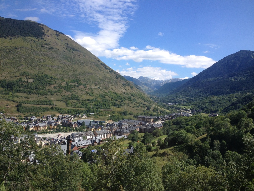
 Vielha from the tunnel
 So I just got back from hiking in the Catalan Pyrenees. The five of us stayed at an "aparthotel" in a small mountain village called Vielha in the Val d'Aran Valley. We only stayed for 2 nights and 2 days total, but it was a blast.
Brief History: The first people settled in the Val D'Aran about 6000 years ago, known as the Arans. Due to its isolation amongst 3000m peaks, this culture has remained intact. It is part of the Basque Culture Region, which is only found in the Pyrenees. Many of the buildings in the town were built in the 11-13th centuries by the short-lived Roman occupation and the few roads present are directly based off the Roman street/road layout. Vielha was once 100% isolated from November until June, until 1948, when the Vielha Tunnel was built. It is a long tunnel that brings you underneath a high mountain pass and was once the longest tunnel in the world, at around 5km. During the summer months (pre-tunnel construction), people were forced to hike the 2500m elevation mountain pass, a distance of roughly 10km, to get to the Val d'Aran.
Brief History: The first people settled in the Val D'Aran about 6000 years ago, known as the Arans. Due to its isolation amongst 3000m peaks, this culture has remained intact. It is part of the Basque Culture Region, which is only found in the Pyrenees. Many of the buildings in the town were built in the 11-13th centuries by the short-lived Roman occupation and the few roads present are directly based off the Roman street/road layout. Vielha was once 100% isolated from November until June, until 1948, when the Vielha Tunnel was built. It is a long tunnel that brings you underneath a high mountain pass and was once the longest tunnel in the world, at around 5km. During the summer months (pre-tunnel construction), people were forced to hike the 2500m elevation mountain pass, a distance of roughly 10km, to get to the Val d'Aran.
 View of a neighboring peak (photo by Nate)
 The Ascent: We found out how hard it was to traverse these mountains first hand, right next to the south entrance of the Vielha tunnel. We planned to hike a peak called Tuc de Molieres, with an elevation of 3010m. We couldn't start the ascent until 11:30, since that was the earliest bus. It was supposed to be a short-distance hike, but the route climbs nearly 5000ft of vertical before the "trail" reaches the summit. Plus, some of the rocks and escarpments were very dangerous and physically demanding to climb. We left the girls at around 13:30 and continued on towards the peak. Zach gave it his all, but exhausted around 14:30. Nate watched him traverse back down the steepest part to make sure he was okay. Nate and I continued on, but at this point, we were literally rock-climbing 3-4 meter vertical rock-faces at a time. Although we only had about a kilometer to go in horizontal distance until the peak, it was going to be all rock-climbing, according to my topo-map. We decided to make a change-in-plans and climb up to a closer summit at an elevation of 2797m (3.28ft per meter). We reached this summit at about 16:30 and took many photos. We were above the clouds and viewed the many glaciers above 2500m. The midday temperatures were only in the 40s fahrenheit at the peak. In fact, the shady sides of the cliffs we climbed were still frozen.
Wildlife: We saw golden-colored gofers (Marmota marmota) and possibly the sign of Chamois (Rupicapra rupicapra) or more probable, the Red Deer (Cervus elapses). In the valley, there were large herds of domesticated sheep that wore bells around their necks, I guess for protection/organization.
Wildlife: We saw golden-colored gofers (Marmota marmota) and possibly the sign of Chamois (Rupicapra rupicapra) or more probable, the Red Deer (Cervus elapses). In the valley, there were large herds of domesticated sheep that wore bells around their necks, I guess for protection/organization.
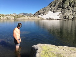 Numbing, pre-dive
 The Descent: On the way back down, we were able to find a much more well-defined trail that we didn't follow much at all on the way up. That would have saved us a lot of energy, but it was hard to see where to go when climbing up such steep terrain. However, from the top, it was easy to see. On the way back down we stopped at a pond at the bottom of a glacier, at about 2300m in elevation. Both Nate and I jumped in and, as expected, the water was frigid. It could not have been above 40 degrees F. I saw these lakes on the map before we began the hike, so I brought my goggles and was able to swim to the bottom of the pool. The water was crystal clear, but I only lasted for a minute or two before my body went numb. Luckily, immediately after getting out of the water, I felt relief from the cold due to the direct sunlight. That was definitely the most refreshing swim of my life. After getting through the steep descent from the peak and ponds, Nate and I ran through a valley along a stream that originated from the glacial lakes. We had to make it to the bus by 18:42, so we were cruising. We even made it to the bus stop 20 minutes early, where Zach was waiting for us.
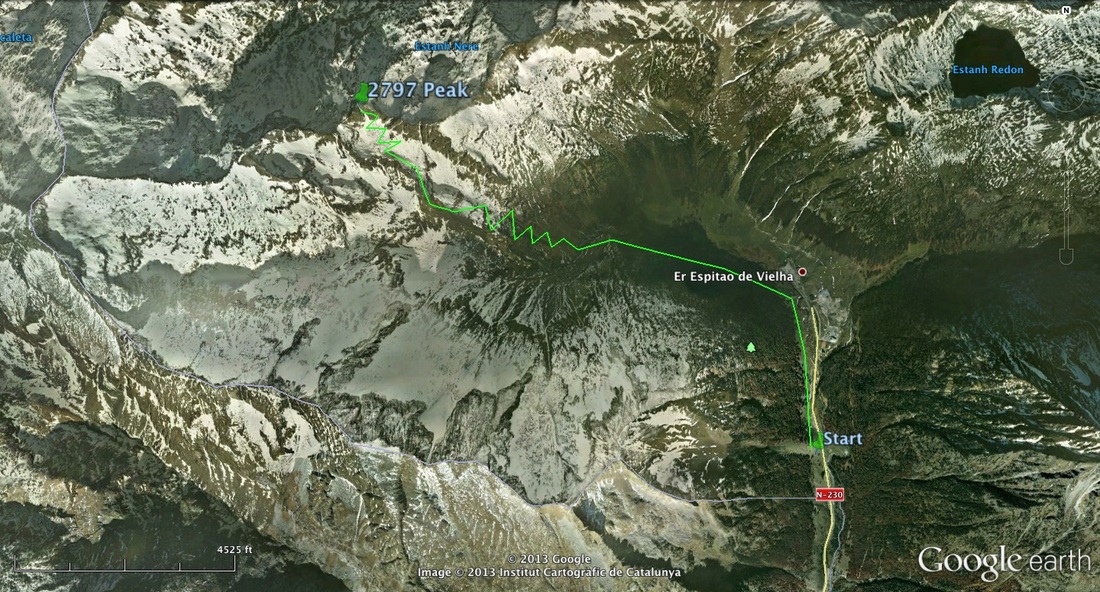 This is approximately the route we took
 Back to Town: Our early arrival didn't matter though, because for whatever reason, the bus drove by and didn't stop. He must of saw us too late. Once you enter the tunnel, there is no turning around for roughly 7km. We ended up going into one of the two Refuge "Huts" there, one of which is a stone building built in the 16th century. It's original purpose was to serve as a stopping point for people about to go over the mountain pass, pre-tunnel construction. Fortunately, Zach knows a little Spanish, so we were able to call a taxi, which was 20 euros, but it got the job done. The girls did the same earlier in the day.
Culture: The primary languages of the Val d'Aran are Catalan, Castilian Spanish, and French. No English. We had to show our passports upon arrival in Vielha because we were only 25km from the French border and the mountain range to the north is the boundary of France and Spain. We went to the same Cafe, Cafe Bomba, every morning and on the last morning, the owner/only person working there, brought us a free shot of what I think was Scotch. He couldn't speak English, but was wearing a Simpsons t-shirt every time I saw him. The Cafes in Spain are a cafe/bakery from 9:00 to 14:00 and a bar/dinner place from 16:00 to 20:00-2:00, after the daily siesta.
Culture: The primary languages of the Val d'Aran are Catalan, Castilian Spanish, and French. No English. We had to show our passports upon arrival in Vielha because we were only 25km from the French border and the mountain range to the north is the boundary of France and Spain. We went to the same Cafe, Cafe Bomba, every morning and on the last morning, the owner/only person working there, brought us a free shot of what I think was Scotch. He couldn't speak English, but was wearing a Simpsons t-shirt every time I saw him. The Cafes in Spain are a cafe/bakery from 9:00 to 14:00 and a bar/dinner place from 16:00 to 20:00-2:00, after the daily siesta.
 The beginning of the steep ascent (photo by Nate)
 Our adventure in the Pyrenees is unforgettable and I will either make another trip there while staying in Barcelona or come back at a later time to hike and/or ski 3000m plus peaks amid an unique culture and beautiful countryside.
 RSS Feed